RolePlay onLine RPoL Logo

, welcome to The Morrow Project PF 010 The Final Watch

02:41, 18th April 2024 (GMT+0)

Maps and Autonav Information.

Posted by Project DirectorFor group 0
Project Director
GM, 171 posts
Papa-2
Thu 26 May 2016
at 21:37
  • msg #1

Maps and Autonav Information

This thread is for Autonav and map information.

Tony
Project Director
GM, 172 posts
Papa-2
Thu 26 May 2016
at 21:37
  • msg #2

Maps and Autonav Information


This message was last edited by the GM at 21:38, Thu 26 May 2016.
Project Director
GM, 489 posts
Papa-2
Fri 30 Jun 2017
at 04:21
  • msg #3

Maps and Autonav Information

10Start Turn 9


                                        ^
                                        |
                                      *[A]*
                                      *   *
                                      *   *
                                      *   *
                                      *   *
                                      *   *
                                    XX* X XX
 N-->                                =======
                                      *   *
                                      *   *
                                      *   *
               I                      *   *
***************I**********************    *
        DDDD[R]I[W]                   [B]*
***************I************************
               I

|_______|
   30m

A = Jenna
B = Scout (Dylan, Kim)
C = Ranger (Tim, Jimmy. Alice, Lena Tina, Bobby)
W = Filat, Daniel
X = Ambushers? 5m height.
H = Horsemen?
D = Dismounts (Jimmy, Tina, Bobby, Lina)

*** = Tree line (narrow trail, 10-20m Douglas firs.
I   = Felled tree

Project Director
GM, 687 posts
Papa-2
Wed 27 Mar 2019
at 04:23
  • msg #4

Maps and Autonav Information

Project Director
GM, 695 posts
Papa-2
Tue 30 Apr 2019
at 03:01
  • msg #5

Maps and Autonav Information

Project Director
GM, 699 posts
Papa-2
Mon 20 May 2019
at 10:34
  • msg #6

Maps and Autonav Information


Project Director
GM, 700 posts
Papa-2
Mon 20 May 2019
at 10:41
  • msg #7

Maps and Autonav Information


Project Director
GM, 777 posts
Papa-2
Wed 8 Jul 2020
at 04:36
  • msg #8

Maps and Autonav Information

https://ngmdb.usgs.gov/topovie...13/47.9251/-124.6782

To get the best version of this map, click on Options (gear) on the right. Then de-select Map Boundaries. (This gets rid of the red tint.) Then to get the USGS Map go to the upper left corner and click on the round USGS symbol.
This message was last edited by the GM at 04:42, Wed 08 July 2020.
Project Director
GM, 875 posts
Papa-2
Fri 25 Feb 2022
at 18:42
  • msg #9

Maps and Autonav Information

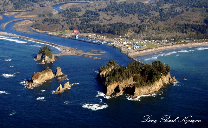
Due to the lack of maintenance of the breakwater at the mouth of the Quillayute river the river has reverted to its previous natural course. Therefore Rialto beach, on the left, now connects James Island (bigger island on the left) and Little James Is. (smaller island on the left) to the mainland.


This message was last edited by the GM at 19:27, Fri 25 Feb 2022.
Sign In